$350
Virginia Beach, Virginia
Category
-
Length
-
Posted Over 1 Month
If you are reading this ad, then this item is still for sale. Unlike many (inconsiderate) posters, when I sell an item I immediately delete the ad. To purchase, you must bring exact change (CASH).
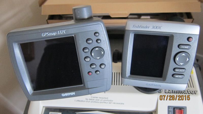
NO TEXTS, NO TRADES. CASH ONLY, EXACT CHANGE, $350 FIRM. Will sell units separately if interested. GPSMAP - $295. Fishfinder - $95.
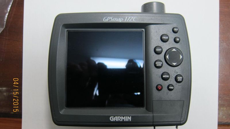
Units work great. Have no screen dead pixels, scratches etc. Selling only because I upgraded to a newer model with a bigger screen that, in my old age, I can see better. Includes covers, mounting brackets, connecting cables, all documentation (on CD).
GPSMAP includes built in antenna, Built in Worldwide Marine Base Map, Blue Chart Data Card for Southeast Florida, Inland Lakes Charts for entire USA, Data Programmer and Data Card, Manual, Software Drivers, NEMA 0183 Network Compatible, Tide Tables, Much More.
The Fishfinder 300C has a super bright, high resolution 3.5" (8.89 cm) QVGA color display with improved user interface, plus Ultrascroll® for screen updates at live-action speeds. The 300C comes with a dual beam transducer, which provides excellent coverage in shallow waters.
Benefit from High Performance Sonar
The 300C features the high performance sonar receiver found in most of the Garmin marine lineup.
Other Features
Power output: 150 W (RMS) 1,200 W (peak to peak)
Auto Gain setting adjusts sonar sensitivity automatically
See-Thru® technology shows weak and strong returns simultaneously
Round flasher display mode
Whiteline shows you how thick the bottom is
2X and 4X automatic and manual zoom
Battery voltage indicator
Single NMEA 0183 output
GPSMAP Specs.....
Physical & Performance
Physical dimensions6.3" x 4.9" x 2.8" (15.7 x 12.2 x 7.1 cm)
Display size, WxH3.2" x 3.2" (8.1 x 8.1 cm)
Display resolution, WxH320 x 320 pixels
Display type256-color CSTN
Weight15.6 oz (442 g)
Water ratingIPX7
AntennaInternal with external connection
NMEA 0183 compatible
Power consumptionMax power usage at 13.8 Vdc: 6W
Mounting optionsBail or Flush
Garmin Marine Network™ portsNone
Maps & Memory
Accepts data cards1 Garmin Data Card
Waypoints3,000
Routes50
Track log10,000 points
Chartplotter Features
Garmin Sonar compatibleYes (with optional GSD 20 or GSD 21)
Supports DSC (displays position data from DSC-capable VHF radio)
Tide tables
GSD™ Black Box sonar support
Sonar Features & Specifications
Dual-frequency (50/200 kHz) sonar capableYes (with compatible black box sonar)
Dual-beam (77/200 kHz) sonar capableYes (with compatible black box sonar)
Connections
NMEA 0183 input ports2
NMEA 0183 output ports2
Fishfinder 300c Specs
Physical & Performance
Physical dimensions4.5" x 4.5" x 2.4" (11.4 x 11.4 x 6.1 cm)
Display size, WxH2.1" x 2.8", 3.5" diagonal (5.3 x 7.1 cm, 8.9 cm diagonal)
Display resolution, WxH240 x 320 pixels
Display typeQVGA
Weight9.6 oz (272 g)
Water ratingIPX7
Audible alarms
Sonar Features & Specifications
Dual-beam (77/200 kHz) sonar capable
Frequencies supported80/200 kHz (dual beam)
Transmit powerDual Beam, 150 W (RMS), 1,200 Watts (peak to peak)
Maximum depth900 ft (dual beam)
Bottom lock (shows return from the bottom up)
Water temperature log and graph